FIRINGA le site
Le site Firinga se spécialise dans le suivi des 'cyclones tropicaux du Sud-Ouest de l'Océan Indien'
Hary - Le 09 mars 2002 à 21:40 UTC - Hary atteint le stade suprême du cyclone tropical TRES intense, à proximité des côtes Nord-Est Malgaches ! Catégorie 5 / 5.
Les différents stades atteints par HARY
Stades atteints | Date de l'évolution |
|
---|---|---|
Dépression tropicale |
05.03.2002 à 18 UTC |
![]() |
Tempête tropicale modérée |
06.03.2002 à 06 UTC |
![]() |
Perturbation tropicale |
05.03.2002 à 00 UTC |
![]() |
Forte tempête tropicale |
07.03.2002 à 00 UTC |
![]() |
Cyclone tropical |
07.03.2002 à 18 UTC |
![]() |
Cyclone tropical intense |
08.03.2002 à 00 UTC |
![]() |
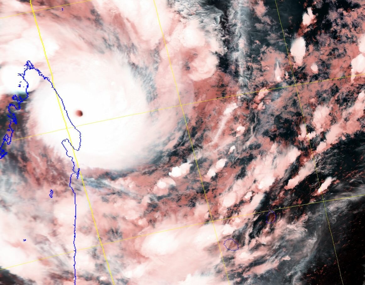
Cyclone tropical très intense |
09.03.2002 à 21 UTC |
![]() |
Cyclone tropical intense |
10.03.2002 à 15 UTC |
![]() |
Cyclone tropical |
12.03.2002 à 06 UTC |
![]() |
Forte tempête tropicale |
13.03.2002 à 00 UTC |
![]() |
Dépression extra-tropicale |
13.03.2002 à 12 UTC |
![]() |
Intensité maximale, selon les agences Météo-France et JTWC
Valeurs maximales atteintes par HARY, le 10 mars 2002 à 00 UTC |
|
---|---|
Intensité sur l'échelle de Dvorak (Ci) | 7,0/8,0 |
Intensité sur la classification Australienne | 5/5 |
Pression estimée au centre | 905 mb |
Vent moyen sur 10 mn ( donnée Météo-France ) | 222 Km/h, 120 Kt |
Vent moyen sur 1 mn ( donnée Météo-France ) | 250 Km/h, 135 Kt |
Vent moyen sur 1 mn ( donnée JTWC ) | 259 Km/h, 140 Kt |
Vent moyen sur 1 mn (intensité atteinte la plus probable) | 259 Km/h, 140 Kt |
Rafales | 322 Km/h, 174 Kt |
Influence sur les terres
Conclusion
Cyclone Harry developed on March 05 to the southwest of Diego Garcia. Hary peaked with 260 km/h (160 mph) winds, the strongest of the season, as it brushed the northeastern coast of Madagascar. Hary then turned southeast and dissipated on March 15. There were only minor effects on land. One person was killed in relation to the storm after being electrocuted by a downed power line. At least four bridges were also destroyed by the storm.